|
|
Ayer Itam - Penang
Part1 -My Kampong
|
|
Ayer Itam - Penang
Part1 -My Kampong
Ayer Itam - Early Days Part 1- Kampong Melayu #1 Ayer Itam - Picture dating back to earliest time This is supposing Ayer Itam Road around 1910. My guess, is that it is that part of the present Boundary Road where the road crosses the river judging from the bend and the birdge
#2 sketch plan of Ayer Itam 1909 This is map showing the electric tram going from Balik Pulau Road to the Jetty. Note the road to Penang Hill was not shown yet, meaning before that era. The road to Paya Terubong Road ended at the Happy Valley, a spot a little distance away from Sungei Ayer Itam bridge. Clearly shown was the principal trail behind the Kek Loke Si temple - passing the area where the present Air Itam Dam. I am very happy to get hold of this sketch, in helping me to relate my experiences about this place called Ayer Itam. The sequence of events appears obvious. First a group of farmers were sent to the hills opposite the Kek Loke Si present site. They could work on the hill slopes and from there follow the track besides Kek Loke Si get over the pass and continued working on that western slopes. That happened and could still remain so. Except it has changed - from planting of Cloves and nutmeg and now into having Durian trees.
#3 Electric Tram for Ayer Itam Then came the real development. The building of the Penang Hill Railway. Work started in 1901. A better access road to Ayer Itam was needed. At the junction of Rifle Range Road, the new route was straighter and avoiding that slight depression in Boundary Road. From the position of today's Rifle Range Market, then the bend at Chung Ling Chinese School, it was then a beeline for the base of the Hill station This second picture showing showed the Electric Tram, introduced in Penang 1905. Here showing the tracks still interspersed with grasses. While experimental work was continuing on the Hill Railway from 1909 through to its opening in 1923. Transportation was required. So not surprising that the pictures must have shown the scene before 1920 times. Not so much for farm produce but for workers and then tourist to Penang Hills. It was opened on 21st, October 1923. Funny must be a good day as it co-incided with the same day that Penang Free School celebrates their anniversary.
With the tram route established, the Malays were gathered and they were located a piece of land at the end of Boundary road and it became Kampong Melayu. Just nicely out of the Georgetown area.. Took the British close to 100 years to realize this plan. Towards the tail end of 1800, Farms for the spices were well established and a small settlement in the valley at the foot of the hills sprung up. That settlement was now known as Ayer Itam. Following the looks of the largest brook that flows through the settlement and whose water was really dark green, Ayer Itam thus came in being. The water of the other brooks like the one from Penang Hill were clear and transparent. #4 The Rifle range Road 1910 Real rural with coconut trees
#5 The Air Itam main Road 1910 An imprived main Road for Air Itam, scene was that of low population, still rural
#6 The Chung Ling High School Chung Ling primary school was established on 9h February1917 with 81 pupils/ it had its schoo; building at No. 8 Malay Street. Later the school was located into a better place, that time was a bungalow at No. 65 McAlister Road. A year later the school expended to include the provision of lower secondary education. In 1931 a piece of land was acquired in Kampung Batu, Air Itam, for construction of a proper school. The making of the new school building started in 1934 and completed in September the following year. Here is the picture which remains until this time.
#7 The Shell station 1960's This is along Ayer Itam Road having passed by Boundary road junction. Directly opposite Jalan Tiga. The Shell station is still there. Notice that light coloured patch in the center among the hills? That's bombed crater. By now overgrown with jungle foliage.
This place after Boundary Road was then
viewed as very
central, just out of the demarcation area reserved for Malays and
not getting involved with those busy farmers gathering at the market
place. The land just opposite this Shell Station became the
"Millionaire Row" of Ayer Itam. Yes, no millionaire as yet at that time, I know! But
the influential
merchants were getting their plot of land and having their bungalow built
. Like what we now call affluence suburbs. My friend and current
neighbor now a Dr Tan, his family owned one of those few houses. No
pictures as the lands had changed hands and the vicinity transformed
and occupied by prayers houses. The next picture below fromthe present
day gives that clue.
#8 Shell station -Today's scene This is along Ayer Itam Road having passed Boundary road. Directly opposite Jalan Tiga, it is a short dead end road.. The station is still there. After the station, we move on to the next spot - Zoo Road
#9A Jalan Air Puteh But before reaching Zoo Road. Jalan Air Puteh. That elusive Choong Nam Cinema, tugged away on the second road
#9B Now a FGA church This is today's scene of what used to the 3rd Cinema for Air Itam. Right at the entrance of Jalan Air Puteh
First Zoo in Malaysia Ha! ha! No kidding - no one talked about it in Ayer Itam and no one is that curious. Not until now with Google and internet, the story behind the name "Zoo Road" started surfacing. As a kid, we had lots of places to go playing and hardly came down to the level land this far east. Our playgrounds more interesting were near the hills. Yes! Did pondering why this particular Zoo Road area was not that well populated compared the few other other roads we had in Ayer Itam. My friend Rosy was brought up in Zoo Road. That was history, now finally they had made a bridge for pedestrians to cross the Ayer Itam River over the flats in Jalan Pisang. # 11 That's how Jalan Air Itam Road looks like 1940's The landmark is the bridge before Zoo entrance
# 11 The Zoo Road Entrance
#11 The "Penang" Zoo Started by a monk Fa Kong in 1920. The place could boast of having 10 different species of rare animals like Tigers and Lions. Animals caged but these cages blended in well with Lily ponds, bridges and arches of Chinese Garden design style. Critics came in 1929 where 20 Orang Utans were cramped in one confined space. Again reported in 1929 the animals were mistreated. Another scandal surfaced in 1932. where the head monk Chan Tam Lan, of the Burma Road Temple was charged with running an illegal lottery to raise funds for the upkeep of the Zoo. There were more! Anyway the Zoo was closed before the World War II. As for memory sake even we had not seen this scene, a small picture giving sample glimpse of the landscape for the Zoo - would help to imagine. This would be how it would have looked like from the outside
C. M. Hashim Bungalow # 12 C. M. Hashim House Big question mark? Actually no need for uncertainty. There clearly marked on the pillar This house marked Penawar C. M Hashim. This House belongs to C.M. Hashim a dignitary who died in March 1969. More detail are available on Face book Penawar C. M. Hashim. We never paid much notice to this bungalow other than admiring how huge the compound is! But, on the right edge of the compound was the Penang Hill River bordered by clumps of bamboo growing on its bank. Right across the river is the village's only "Bar". The Tody" shop. We young boys knew nothing about Tody too, besides knowing that it would be the place where the the Indians labourers would gather and get drunk. Funny ah! the whites would be doing the same in Hongkong Bar in Chulia Street.
# 13 Chor Sin Kheng Road We really love passing this road as a short cut to the rear end of the road to my house. What's so special about this road? Looking back this is the first modern housing estate in Ayer Itam. We did not know what a housing estate was and what is so special. The road and the houses looked orderly and modern compared to the assortments of village type houses that we were used to seeing.
# 13A Petron Petrol Station My regular filing station opposite the bungalow
Part 2 - The Hill Railway Area 升旗山脚 -The old de-facto town center # 14 Ayer Itam Reservoir This pictures bring back lots of fond memories. The water for the reservoir comes direct from the Ayer Itam Dam. Good clean mountain water After passing through the filtration, we all drink this water direct from the tap with confidence as saw it collected and processed. A short winding road led up to the Reservoir. the road was open. Right below the reservoir would the Granite Quarry in Hye Keat Estate. Punctually at noon each day, we would be reminded of the series of loud blasting sounds made by explosives. This must be a rather old picture. Point to note the clock tower was not built yet and many plots of land on the Penang Hill slopes opened up.
Eastern Garden Amusement Park This is actually a 4 ways junction. Clockwise- Right at the junction to turn into Hye Keat Estate, squeezed in between the NEB sub station and the Kong Beng Cinema. Second to town, third to Ayer Itam and lastly forth to Penang Hills. Lots of memories for me. Luckily they are all good ones. The power supplies to the valley or part of the village would be cut off at 8.30pm and very quickly it would be reinstated. This is the present look. The corner land where Glory cinema used to be, just right of the 118 Cafe. Long ago it was also a small coffee shop. #15 Junction opposite the memorial The new round-about here is used to be a 4-ways junction. Right opposite the TNB power station was this cinema. I have got its right this time "Glory" or "Kong Beng" in Chinese. The cinema was built facing and to compliment the Eastern Amusement Park
#16 Eastern Garden Amusement Park - Swimming pool Although closed in mid 1950's. The park intact was still there when I was old enough to be mooching around. Looking back, I just wonder how a small settlement like Air Itam could keep an amusement park running. Anyway it is just a hyped up swimming pool with some frills. Later on poor management and statistic of too frequent drowning led to the place to be deserted and closed.
# 17 Gathering place for Air Itam Folks The new Ambassador Cinema changed the landscape of the whole vicinity. The swimming pool dismantled and a new building came up to take over the slot left behind by the Amusement Park Activity in Air Itam villages went like this. The Air Itam wet market would be the gathering place from 6am until noon. There was a lull. Then by the afternoon, residents started gathering here. Foot of Penang Hills. It is still the same up till now - my Mee Goreng opens at 3 pm Got this picture to reflect on that short lived Tokyo Cafe
#19A The Ambassador Cinema - Kok Pin A clearer picture of Ambassador cinema. The Ambassador cinema [Kok Ping] continued to be opened for some time until mid 60's when the Lai Lai Super Store chain took over the whole area.
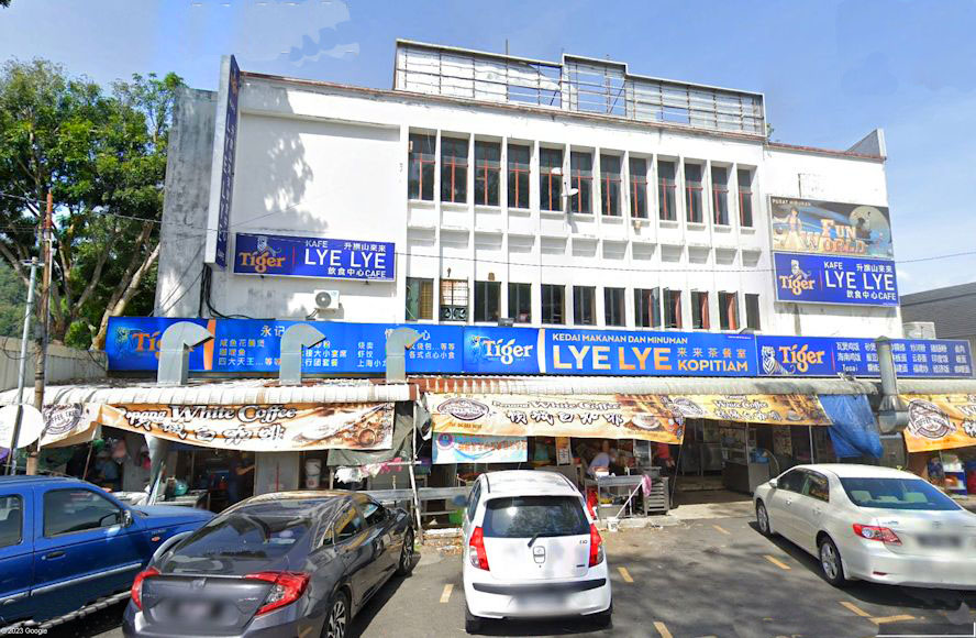
# 19B Then came "Lye Lye" Departmental Store Was almost the tale-end of the movie fad. The cinema Hall gave way to a Departmental Store
Cinema. #19C Building Taken over and converted into Lai Lai Shopping Center Found the picture of the Lai Lai Departmental Store
#20A Today's scene again - The Lye Lye Coffee Shop Lai Lai Super Store - an expansion plan from the very successful Sui Wah general Store in Air Itam market was doing very well when they first started. They took over the land that was once the swimming pool. After a very successful launch in time to come, patronage slowed. Fast forward - in another era, later in early 70's, larger chain supermarket - The likes of Giant opened up in Farlim. Lai Lai Super Store was phased out. Likewise Giant the new comer, also suffered the same fate. They too closed lately and now it is run as a Hero Outlet After the many evolutions - That's all left to show for today's viewing
#20B The present day -the 2 plots of land Before the Round about was installed, in this area, this is actually a 4 ways junction. But let's talk about the 2 tiny plots of lad opposite the memorial. Today there is a clear lane that divides the 2 plots. The left side one plot of land Left - Eastern Amusement Park that later became the Ambassador Cinema, then went on to become Lye Lye Super Store then again became Lye Lye Coffee shop. The right was Glory Cinema then and was then a Coffee Shop which again changed hands to become the present name 118 Cafe Both cinemas were in different era, never co-exited at any one time.
#21 Road In - Hye Keat Estate & the quarry The two landmarks still exit. The electric generator station we once got so used to as a kid and the iconic landmark clock tower at the reservoir
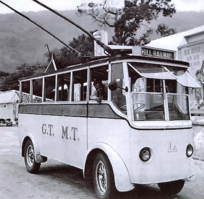
#22 Dedicated Tram - Hill Railway A very precious picture indeed, capture the sight of a dedicated Tram for this one kilometer journey to the lower station of Penang Hill Railway. At the back or side poster of the Ambassador cinema
# 23 Columbarium Miu Heong Lum A fairly new picture of the columbarium in color. Only busy once a year during Cheng Beng Season
# 24 Columbarium Miu Heong Lum Another picture of the same place taken from the year 2019
Anti-War Memorial Park My childhood's playground # 25 The Overseas Chinese Memorial Anti-War Memorial Park Pictures showing both were iconic and bring back much memories. I read that some 800 incomplete set of skeleton collected all over Penang were then buried under the obelisk I am not sure that this colored pictures could be a post 1974 pictures. Ricksaw cart were no longer in use by then. The City council bus was still using electric trams
# 26 Then Double Decker Bus Yes another one of those mysterious colored pictures This must be in the early 1960's. Good to see the days when the round about at the Memorial was not installed then. Judging from the background in this pictures - the bombed crater in the hill slope [above the bus] clearly visible and looking fresh. The jungle have not taken over barren crater.
# 27 Every structure around here are the good old places where I played Lucky I found one picture to show the bare looks of this important cross roads junction. It was without the round-about then. Also missing at the monument, the model of the truck was not there during my time. When that trunk was installed I was long gone. In the evening we just play on the raised platform.
# 28 The Penang Hill Round-About Oh! The modern day's scene totally changed now. Compare with the picture above, We lost that nice scene.
# 29 The Hill Railway Road No one could miss seeing this road. The Penang Hill Railways Road. It is iconic to Ayer Itam. Anyway it is a dead end road, going no where but to the Hill station, settlement and back
# 30 Ayer Itam Health Clinic It was quite a straight forward building unlike as shown here. This the first and only Government clinic in Ayer Itam for a long time. By now more clinics within Air Itam had opened up. This was a sacred place to go to when we were unwell. "Touch Wood" I never visited the place officially but I remember this place as "sacred" or "savior" as I termed it. It was devoted to those who were really sick and needed medical attention. Very unlike today's trend of seeking assistance because it is a free service. Jammed packed daily to take care of people going for routine follow-up and those seeking their monthly medication
# 31 Nurses Quarters We were very close to the head nurse that managed the clinic. She was given a living quarter in the compound of the clinic and next to it. On the left edge of this picture would be the first and the same house until now. In those early years, the lawn in front of the house was an open field, which today is fenced up and filled as car park A friend of my mother, those "Amah Chea" from the same kampong in China worked as a domestic help. The nurse had a pair of children an Ronnie Looi became my playing buddy for quite a number of years
My house & my school # 32 Kong Min Primary School This is the new branch of the vintage Kong Min school in Ayer Itam. The original school was a small set up at 611-C Balik Pulau Road . It had only a few class rooms. Located at the bottom of the granite walkways to Kek Loke Si Temple. After this, a 3rd branch was built in Paya Terboung Road , I could recalled my parent predicament when I missed the date for the new school term, to get into the Government Primary school. The next option was to get me admitted to this Chinese School. Condition for entry was more lax. So I just stayed on here for one year. When Wellesley Primary school reopen for the next year, I started Primary 1 for the second time. I was tere at Wellesley my 2 years of primary classes. During those years, i I continued to attend Kong Min in night classes for the next 3 years
# 33 Tong Aik's Bungalow Next to the school as direct neighbor was the bungalow house stayed by the owners who operated Tong Aik Departmental Store on Penang Road.
# 34 Jalan Matang Kuching On the lot, it was a Bungalow with a sprawling compound. When I was told that the place was owned by Aw Boon Haw. The chauffeur for the owner was our family friend and was living in a house further down the road.. Aw Boon Haw and his brother, both from British Burma gave Malaysia the famous Tiger Balm Brand. I suppose they had their residents in Singapore and Hongkong. Among his achievement, he started the sin Chew Jit Pau and Chung khiaw Bank. Aw Boon Haw dies in 1954 in Honolulu. The last of his descendant grand daughter Sally Aw relinquished their connection with Haw Par Villa in 1999. Aw Boon Haw having a house in Ayer Itam also explained why both Kek Loke Si Temple and Tua Pek Kong Temple in Ayer Itam received funds from him during the time of their inception. I know nothing of this history other than having played in the compound
# 35 Where is my house in Ayer Itam? Look carefully, right in the center of the picture, the Kek Loke Si Temple complex look so tiny from here. Barely recognized by the light colored Pagoda! This is the main and only Ayer Itam Road leading to the market place. Straight ahead among the bottom of the hills, is Kek Loke Si temple. For the first 15 days during each Lunar New Year, we could see display of those amazing lights, in full view. The important landmark at this spot to watch for and the turning into my house, would the Indian temple on the right, next to the Post Office.
# 36 Well, it is legendary? - Jalan Batu Jantan A view of the road sign itself. In Air Itam, there are no shortage of myths, this bungalow at the start of Jalan Batu Jantan is among one of the myths. So is the name of this road.
# 37 The "Male" Rock The myth? - another 150 meters down the road from the road signage towards the market place, there would be a granite rock about 6 meters long, narrow and lying parallel to the main road.
# 38 The "Female Rock" A picture of the partner's road junction - Jalan Batu Perempuan Then directly opposite to our road junction, there would be the matching Jalan Batu Perempuan. I do not have picture of this matching boulder - Going inside, this road passes by a spread out, flattish rocks made up of 4 segments. Sorry, I couldn't spin more dramatic tales other than mentioning this physical presence as to how the road are named.
Me! Part of history too # 38-2 This is the house, I was brought up with We acquired the house and land way back in 1956. Then in 1959, we replced the wooden shack with a completely new house. Lucky for us, the garden have land for fruit trees. For years now, we had an assortment of fruit bearing trees providing the family with the main supplementary income. At the core, since we shifted in are the 3 Rambutan trees. We had quite a few varieties of fruits. the latest addition,, we tasted the Brazilian Longans - Dimocarpus longan when we were back in Penang in March 2022
#38-3 Pictures for eternal remembrance 1 With so many precious pictures from that house that I have collected and decided to combinr my personal history with that of Air Itam. Sort of "leaving my footprints" behind. So this page has become - Me & Air Itam. For starter this is a picture of my mother
# 38-4 Pictures Me & Air Itam 2 Me! In my youth then in the compound and my eldest daughter.
# 38-5 Pictures Me & Air Itam 3 We had a French car - Peugeot model 504
# 38-6 Pictures Me & Air Itam 4 I love having 2-doors Cars, this is a Mitsubishi Colt Celeste. It was originally painted in Yellow, after an accident in Tanjong Bungah, I had it re-painted into light blue
# 38-7 Me & Air Itam 5 A family portraits with the grandparents
#38-8 Me & Air Itam 6 My lovely wife in her prime
Part 3 - Ayer Itam Market # 42 Present day picture - Taken at little bit forward at the Monsoon Drain Here we could see the strategic white building fronting this junction. That's the new Ayer Itam Police Station. Served as an important spot where both, the Paya Terubong Road and the Balik Pulau Road converged at the point.
# 46 Air Itam Police Station The frontage of the original Police Station building was facing the Air Itam Road junction. as the road approaches the Market area. That picture of the old facade I am still waiting to get. Now the whole complex rebuilt. following Chinese Feng Shui to be facing Jalan Paya Terubong. Left - Paya Terubong Road while - on the right - the Balik Pulau Road
# 47 - The Ayer Itam Estate Office There are 3 estates in the Ayer Itam Valley. The Hye Keat Estates where there is a quarry, The Thean Teik Estates where vegetables husbandry were farmed and lastly this 3rd, the Ayer Itam Estate. It has land that covers the riverine area of the Sungei Pinang River. Meaning sandwiched be our road - Jalan Batu Jantan and Jalan Pisang. No details is mentioned on the internet about this Ayer ItaM Estate. The latest court case involving the 1 MDB, the details showed that the defendant and purportedly the owner is a Mr Tan. For us locally, we only know the land wner as "Bah SaI". The land size in question is close to 260 acres and is under 60 land titles.
# 39 Ayer Itam Estate I had hardly seen this office functioned. Checked on its history, writers vaguely presume that the "estate" would be engaged with rubber planting. The only traces of rubber in Ayer Itam I have seen as a boy were those in a factory named Lee Rubber Estate and that was at the end in Paya Terubong Road.
# 40 Aerial view the Balik Pulau Road - 1923 This is a bird eyes view of the Ayer Itam village taken in 1923. The road leading away from the temple and down to town. Taken from a small peak just behind the pagoda in Kek Loke Si temple. It shows the left of the Air Itam centre intact with quite lot of houses before the 1935 fire.
# 41 Road bend - into the Market Place This point of the Air Itam Road is also an important demarcation for us - outskirt and market square. See the white raised road kerb in the center right side.. This place marks the main monsoon drain which runs across the main Ayer Itam Road..
# 43 Tai Seong Loh Chiun Temple - 太上老君 This is another important landmark for Ayer Itam The temple still exist and fairly patronized. Iy is not one of those house for prayer we paid attention to.
# 46 Away from approach road This was the incoming part of the Air Itam market place, the approach road. Below the 2 pictures showed old wooden house burnt in 1935 on this stretch of road That familiar scene of the valley once more! Looking at the vehicles and scarcity of activities, picture most like to be made in the 50's
# 46-2 Away from approach road I have this picture of the same stretch taken before the great fire. Good evidences. They were not wooden houses but of bricks
# 44 History - The Great Fire of 1935 The fire started at 1.25pm on Feb 3, which was Chinese New Year’s Day, when a gust of wind blew some burning incense papers onto the attap roof of a house opposite the police station. Understandably all house then were made with woods. On that fateful day, 100 houses were destroyed Losses were estimated to cost 200K Strait Dollars. Efforts to raise funds to rebuilt the village were disappointing
Here is a series of 5 pictures trying to freeze the scene of Ayer Itam main thoroughfare. #45 Second Picture of the 1935 fire Approaching the main place from Paya Terubong. Common reference point? The Hill pass [depression between hills] between Penang Hills and Bukit Gantang is a good reference as where we are located an viewing places in the Air Itam Valley floor. It confirms confirm that this stretch of road is Paya Terubong Road Just behind the Police Station
Pictures of Ayer Itam market # 47 Almost Village center Same road and scene a few meters backwards. Stage buses made their last stop and fresh pickup from this point. The main bakery in the village Ka Oon still the old shop
# 48 My bakery shop has expanded The new scene in the year 200! Looking at the vehicles and scarcity of activities, picture most likely to be made in the afternoon
# 49 Old Picture of Sui Wah Departmental Store That's what the sign board says in Chinese. The first and only Mini-market for Ayer Itam
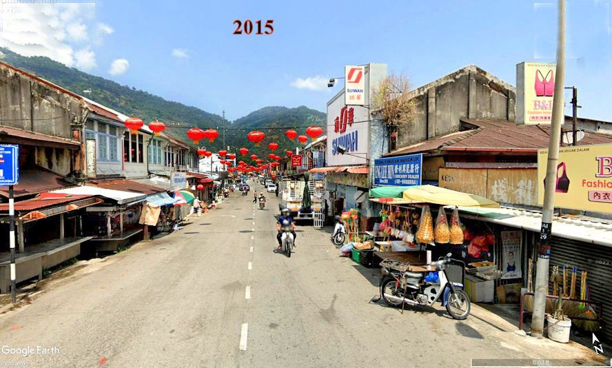
# 50 Sui Wah new frontage in 2015 In the picture was that of the new shop and new comer to the Mini-Market scene, picture done in the mid 70's, This is a typical scene especially in the afternoon when the market had ended for the day. Sui Wah Mini-market entered the Ayer Itam Scene
# 51 Same stretch of road 2017 In contrast - Picture taken a few steps slightly up the road at the bridge - the crowd of Ayer Itam Morning market
# 52 Change of scene - showing traffic flow in 1940 An interesting picture! The spot this picture was taken, showed traffic moving along this road in opposite style as compared with the whole sets of pictures above. This picture looking towards the Bridge. Interesting traffic then from Paya Terubong went straight to the police station. The flow is now must have been done after incorporating the old Balik Pulau Road. The Air Itam Loop came into use.
# 53 The current 2021 Flow Same view 2021, towards the Paya Terubong Bridge, duplicating the today's scene of the above. The present day wet Market [right] was built in year 1956
This page does not end here. The page is getting too long and I have to split the page into another half where more information about places of prayer are included Another notable feature of Air Itam |
|
|
W i t h W i l l W o u l d W a n d e r |
|


.jpg)