
My Thai Odysseys with Beetle
|
By 1995, I have taken up a new hobby "Waterfall Hunting"- a switch over from the past time of going Caving. Most remote waterfalls are in deep jungle without proper access roads. So, there was more needs about going off road with the car before reaching the trailheads. Co-incidentally, it was also at this time, the contemporary craze toying around with 4WD was prevalent, I must do it differently. Then recalling the earlier
days of 1980s when I roamed the country doing
fishing in places so remote. That came to my mind. The car
I depended on was the VW. The vehicle was so light that could be driven on bunds
in the tin mining areas made from sand.
In those occasions when the car got stuck or went off the track, it could be easily pulled
out or even hand lifted. So that's it - the Beetle Can't avoid that! I had to be at the spare part shops for parts to do up my car. Since the Beetle was a phased out model, dealers for spares become a dedicated lot. For hobbyist and I had to mingle with them, The dealers and private owners. How can our car compete? Me, doing off road conditions and rough handling! For a start it is inevitable that i would easily damaged the sensitive fancy changgeh paintwork. With that crucial point in mind, the safest colour would be solid white. A car pated in simple plain colour would be a deterrent as well as hampering our attempts to beautifying the car. A freak thought came up Translate the natural design of our Dalmatian dogs texture as a way to create an attention drawing car. Good! no new invention just use that that as a theme. Following faithfully the size of the various dots, the shape and dispersion style. At last, we made it. That concept turns out unqualified success. We showed our car at Club outings. Our effort and those who had seen the final outcome approved of that unique idea.
|
Northern Thailand
|
Population about
1,292 million inhabitants and with 688 km of away from Bangkok The
city was established by Mangrai in 1262 AD and he reigned from Chiang
Rai until 1296 AD, During that time he founded Chiang Mai and
relocated the capital
over there. The Lanna Kingdom eventually fell to the Burmese in 1558 Chiang Rai is
Thailand's northern most province which forms part of the Golden
Triangle i.e. bordering Laos and Myanmar. Tourist can view both sides
of the Mekong River at the Golden Triangle. This mythical land is distinguished
by its remote hill tribes who live in mountainous terrain
accessible by trekking
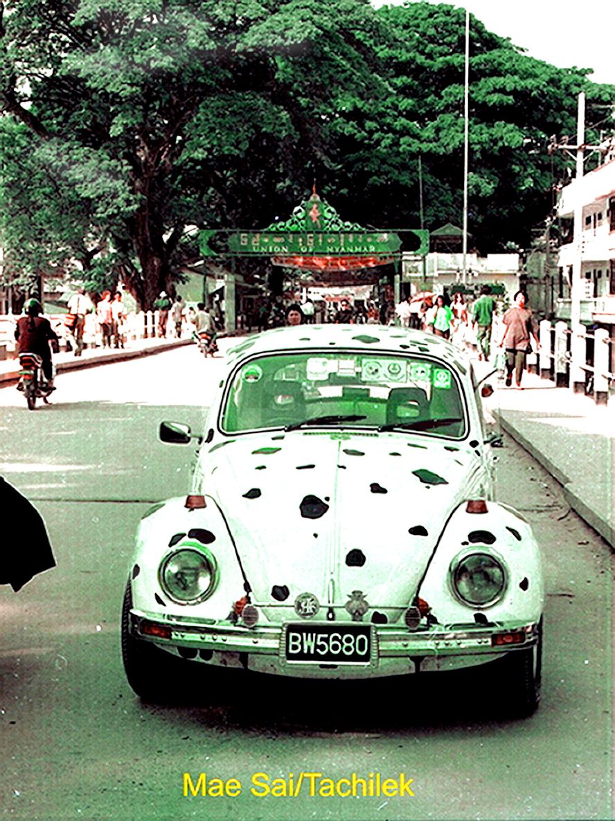
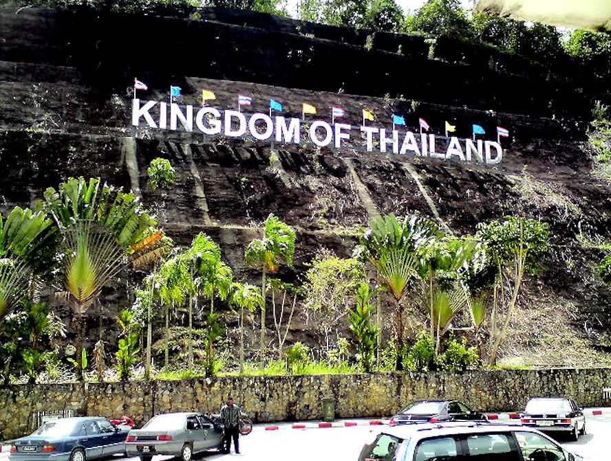
We had met our target! i.e. to reach Mae Sai the Thai border town of Mar Sai. The real reward was even better. We found the third iconic arch for the Golden Triangle to mark that northern most point and also as an accidental bonus we momentarily got our VW into Burmese soil. Not our planned target but in hindsight, the car had covered territories stretching from the furthest south of Thailand at Kolok Golok to the northern most town Mae Sai. That is the entire length of Thai Kingdom. which is calculated to be 2,154 km long. 29.1. Chiang Saen - The "Golden Triangle" Park & View Point 29.2. Chiang Saen - The House of Opium - Museum 29.3. Chiang Saen - Short visit -Phra That Pu Khae Temple 29.4. Chiang Rai - Mae Sai the Border Check Point with Myanmar 29.5. Chiang Rai - Tourist destinations around Mae Sae 29.6. Chiang Rai - Mae Sai - Unique shopping spree in Mae Sai 29.7. A peep into - The Burmese Border Town of Tachilek 29.8. Scenes from the Streets of Mae Sai 29.9. Chiang Rai - The Imperial River House 29.10. Mae Sai The Wang Thong Hotel 29.11. Chiang Rai - Checking out - The Chinese Yunan Restaurant
Chiang Mai is a city in the mountainous region of northern Thailand. Founded in 1296, the then independent Lanna Kingdom ruled from Chiang Mai until 1558.
In Chiang Mai city, the old city areas still remain
in the way as it was and until this day the city area is home to hundreds of
Buddhist temples Most new comers to
Chiang Mai thinks that the city is the stepping stone to eco-adventures. In fact the city itself is a museum and
also a cultural centre.
First, the old city itself is the showcase for the north's indigenous
cultural identity -having diverse dialect, unique cuisine and distinctive
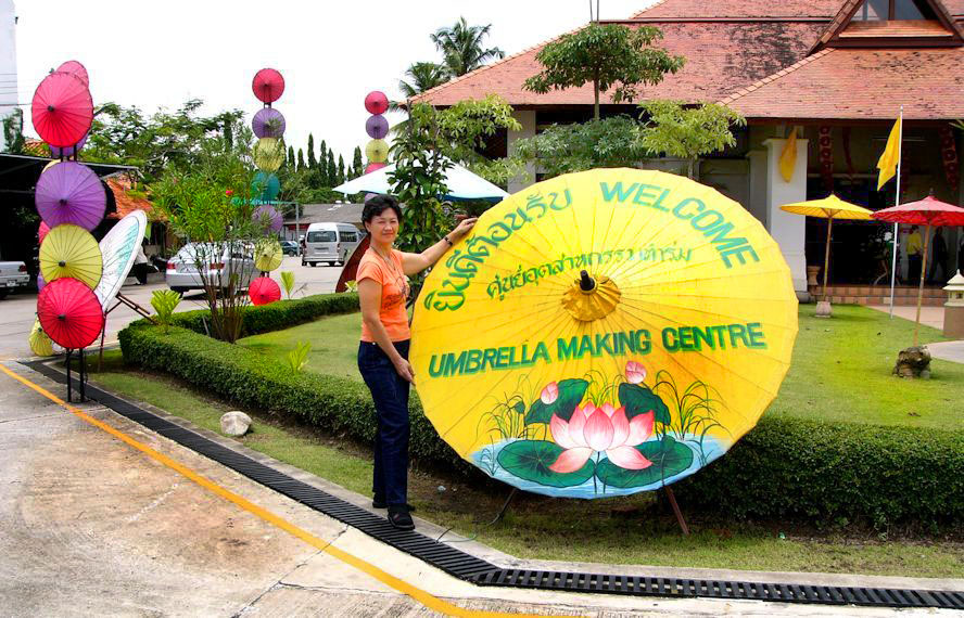
architecture. Even though that Chiang Mai was exotic, our predicament took the top place. We only did a cursory stop at Bor-sang to look at the umbrella making and really to mark our presence..
28.1. Queen Shirikit Botanical Garden 28.3. Old City Walls - Chiang Mai 28.4. Wat Phra That Doi Suthep 28.7. Our Hotel - Holiday Garden Resort 28.8. The Khantoke Dinner & Show 28.9. Night Bazaar Shopping and dining 28.10. The Mae Sa Valley & Sameong 28.11. Bo Sang The Umbrella Village
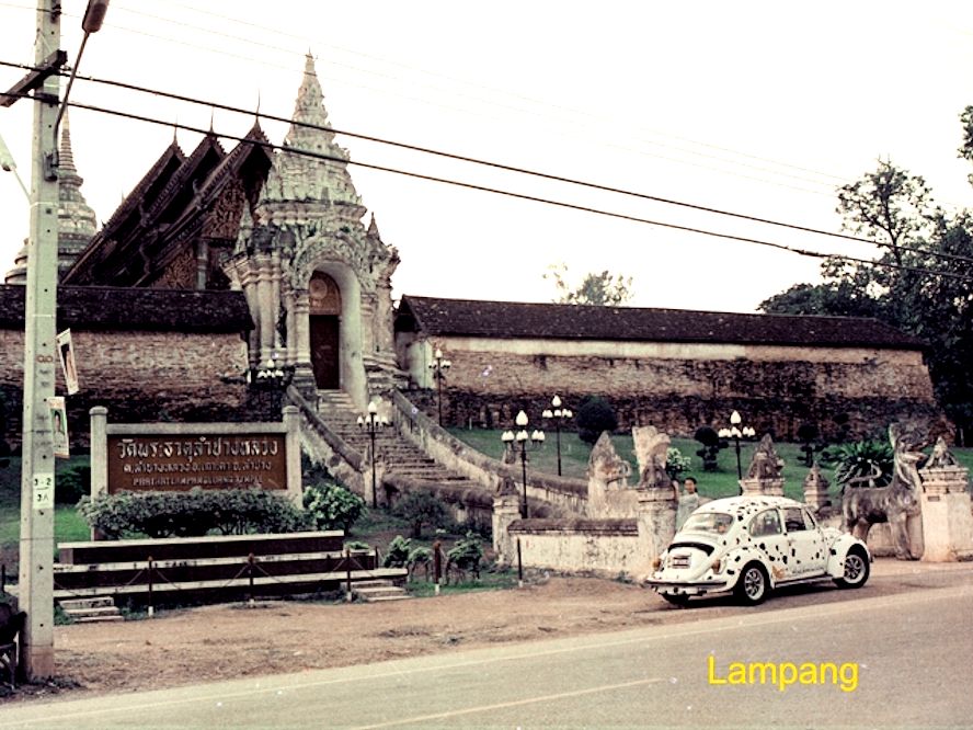
The fault of the car was getting quite concerning. Chiang Mai was a big city! With language difficulty, it was quite hard to get ourselves understood. We decided to carry on driving until we reached a smaller city further south. Yes Lampang! First stop was the dealer for Volvo vehicle, an European make. Very quickly and kindly, they refer us to this specialist workshop across the street. Turn out to be the sole workshop and also an expert VW vans.The Car repaired and we regain our mood to enjoy this city Good hotel, good food and good horse carriage riding Lampang is also
hailed as Nakhon Lampang to reflect that it as a province.
The main city bearing the same name is the 3rd largest city in
northern Thailand. This place is a trading and transportation
hub. This quaint city offered a host of interesting activities. For us we got ourselves a nice hotel, and not missing the opportunity to try their horse carriages ride. Most important we had our car repaired by a local specialist
27.1 The Wat Phrathat Lampang Luang 2702 The VW Repair Shop
Phrae is a small Province in Northern Thailand. Rather insignificant, we had not made any plans or intended to stop over, merely passing by.
On that morning, the noise from
the under carriage of the car was getting very noticeable.
Recalling the last experiences in Surat Thani, where I manage to get
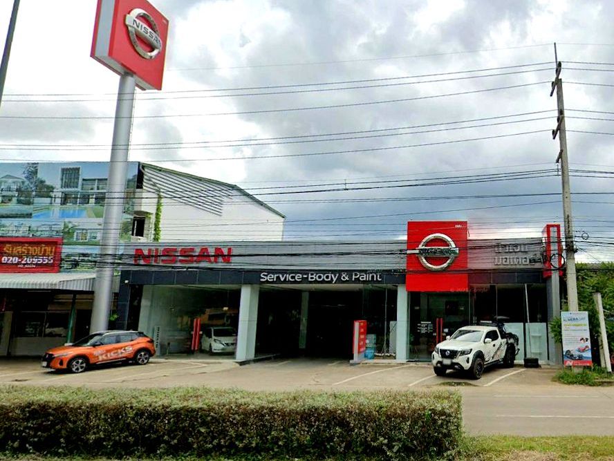
help from the Toyota dealers to get the car fixed, this time in Phrae, I will try the Nissan dealers. After checking,
they informed me that the VW is not a
commonly seen car in Thailand. The noise was internal and they could
not diagnose unless they started stripping. Which again may not have
replacement parts too reassemble the aggregate. So they could not help Nissan Service Centre Shop front
In the comfort of home, it is hard to recall the predicament as that part of Thailand was remote and thinly populated That check up at the Nissan shop was assuring, that there was not danger of a sudden breakdown. Good stop I must say, otherwise I have nothing to report on Phrae. But i've got another province to my collection 26.0 No story for this Province
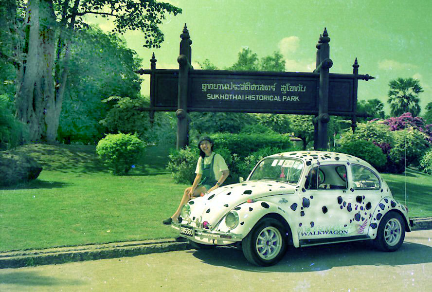
Suhkothai The capital of the Sukhothai kingdom is from the 14th century era. This present historical park is absolutely enormous! The entire Sukhothai Historical Park covers an area of about 70 sq km and contains more than 190 historical ruins. A very widespread site indeed. Sukhothai, located in the northern part of Thailand, holds profound historical significance as the birthplace of the Thai nation. This province is renowned for its ancient ruins, vibrant culture, and tranquil atmosphere, making it a must-visit destination for history enthusiasts and travelers seeking to delve into Thailand's rich heritage. The name "Sukhothai" translates to "Dawn of Happiness," which aptly reflects the province's serene ambiance and the sense of peace it imparts to visitors. The heart of Sukhothai is the UNESCO World Heritage Site of Sukhothai Historical Park, a sprawling complex dotted with meticulously preserved ruins of temples, palaces, and Buddha statues dating back to the 13th and 14th centuries. Exploring this archaeological wonderland is akin to stepping back in time to the golden era of the Sukhothai Kingdom, where art, architecture, and spirituality flourished.
Sukhothai is a magical place with a collection of temples from different era all assembled in one location Yes! very impressive indeed. It is hailed as a historical park of course, with details of the type of architecture and the historical records that goes with them. Still I am left wondering - What does this place represents? 25.1 Sukhothai Historical Site
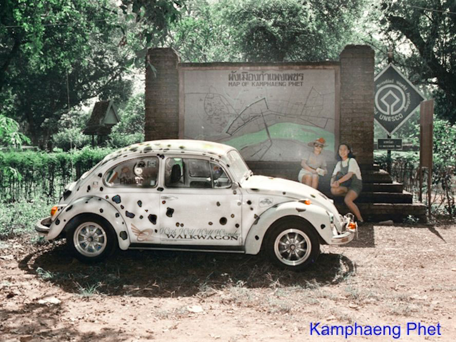
Kamphaeng Phet was a "banana county". Its local speciality were "egg bananas" (kluai khai in Thai), where the Bananas used are only about 10 centimetres (4 inches) long, almost oval shaped (hence the name), This species of Banana is much more aromatic then the run-of-the-mill long, bent banana's varieties sold in most non-tropical countries. Kamphaneng Phet Province exports Bananas worth 200 million Bahts annually. Along Highway AH1 South of the town is the “Talat Kluai khai”, the banana market where dozens of stalls sell various kinds of bananas and other local products. Every year in September the Kluai Khai Festival is held, originally to celebrate the banana harvest, now a fair with performances and entertainment. While i this vicinity, most visitors would also drop by both the Klong Lan National Park and the Mae Wong National Park. Mae Wong is specially beautiful when it is covered in fog during the winter. other shoppers go to the Nahkon Chum Retro Market. Here join the locals to buy handcrafted products in the midst of an atmosphere of merchants dressed in Thai traditional cloths. While so much talked about the most famous Bananas in Kamphaeng Phet, other facts worth mentioning is the Chakungrao Grass Jelly
Our first encounter with archaeological site was Muang Singh in Kanchanaburi. Then where we got this idea of paying a visit to a site certified by UNESCO. In hind sight, we were so lucky to have visited this place at that time. The are since was spruced up for tourism. 23.1. Exploring What's Around the Kampheang Phet area 23. 2. The Klong Lan Waterfalls 23.3. Kampheang Phet UNESCO Historical Site
Phitsanulok city is 369 Kms
north of Bangkok This is an important province in the northern
Thailand. It has the Naresuan and Pibulsonhkram Rajabhat
Universities and also the base for the Thailand Royal Air force.
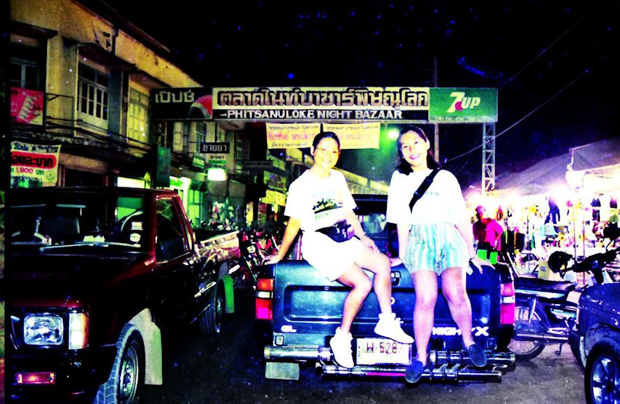
We hit Phitsanulok on our return leg. With the car done up, we were in no hurry. We had moved south throwing behind the uncertainties of retuning peacefully. The mood in contrast was one seeking out a new city for our rest stop.. We enjoyed this city very much. After the few days of heavy anticipation along the way, we switched to one with curiosity This ancient city turned out and gave us those surprises. 30.1 The Riverside Restaurants 30.2 The Night Market in PItlok
30.3 The Phra Buddha Chinnarat |
Central Thailand
|
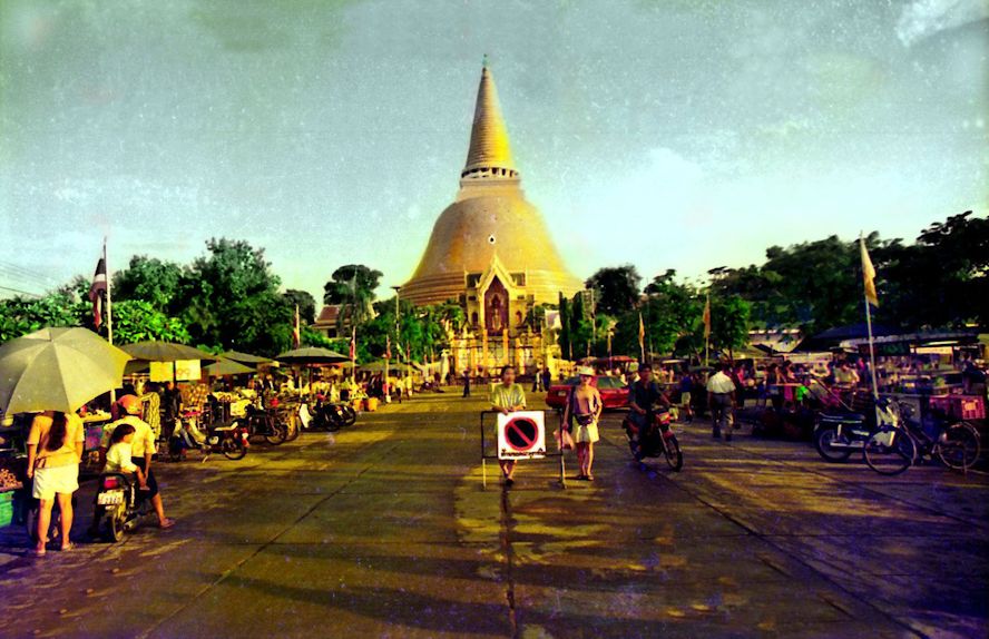
Nahkon Pathom have a land area of 19.85 sq km with a population of 120,657 inhabitants The provincial capital going by the same name is 56 km west of Bangkok. The inpressive landmark for this city is the giant Phra Pathom Chedi. At 127 meters tall, it boast about been the tallest in the world. Nahkon Pathom is a very ancient city with history dating back to the year 40 BC. The Chedi was built in 1853 by King Rama IV. Nahkon Pathom is also a city well known for its abundant of fruits variety and also its cuisine of fruits. Equally well known is its flowers collection as seen in Samppran Riverside. Finally to top it all, annually from the 1-7 September, there would be the Nakhon Pathom Food & Fruits Festival. Among the favourites would be - Pamelo, sweet sausage, crispy pork and pork floss.
In our maiden voyage we were so thrill to see the completion of 1,000 km drive from the city of Hat Yai to reach Central Thailand. We would not join the mad traffic conditions in Bangkok. Nahkon Pathom is the prefect place to rest, Good hotels, competitive prices. Wonderful Night life. Most of all, a nice gate way to sneak up north to Nahkon Sawan without having to get caught with the Ring Roads of Bangkok 18.1 The Chedi of Nahkon Pathom
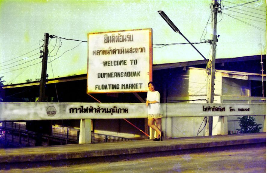
Samut Sahkon is another Province in Central Thailand This province has a land area of 872.3 sq Kms and a population of 584,703 inhabitants. By an act on 9th May 1946 this province came into force. This is rather well known province along Thailand Bay and its main industry is Fishing and large scale salt mining. Among the tourist attractions there is Dolphin view point at the Machanu Shrine on the Mahachai Estuary. Damnoen Saduak Floating Market is one of the most popular in Thailand. The market continue to thrive on the very well maintained canals. It is over 100 years old famous for being the straightest and longest cana. Construction was initiated by King Rama IV in 1866 and completed during the time of King Rama V in 1968. The canal is 32 Kms long and have 200 branches. The plan was to link the Mae Klong River and the Chinese River, imduce ways to facilitate trades This Floating Market grew to its highest point in 1971-73 Damneon Sadauk Floating Market Town Signage
We were regulars to Damneon Saduak Floating Market as we had overnight stop over in Nahkon Pathom. Most of our trips, we would come from the west, Kanchanaburi or if we were to travel in from the north, it would be from Nahkon Sawan. 19.1 The Salt Mines along the Highway 19.2 The Danneon Saduak Floating Market
Kanchanaburi is
famous for its Death Railways built during the WWIi.
The town is 123km west of Bangkok and had s population of
only 31,327 inhabitants. For culture the Bridge made famous by the 1957 movie of the same name. Then the presence of other relics such as the war cemetery, the Hell Fire Pass and the Museum etc assed on the flavour For nature lovers
there are the few beautiful Waterfalls and National Parks with
good diversity of fauna and flora
20.1 Bridge over the River Kwai 20.3 The Sai Yok Noi Waterfalls 20.4 The Hell Fire Pass 20.5 The Huay Khamin Watefalls 20.6 Kanchanaburi Town 20.7 Floating Restaurants in River Kwai 20.8 The Muang Singh Historical Site.
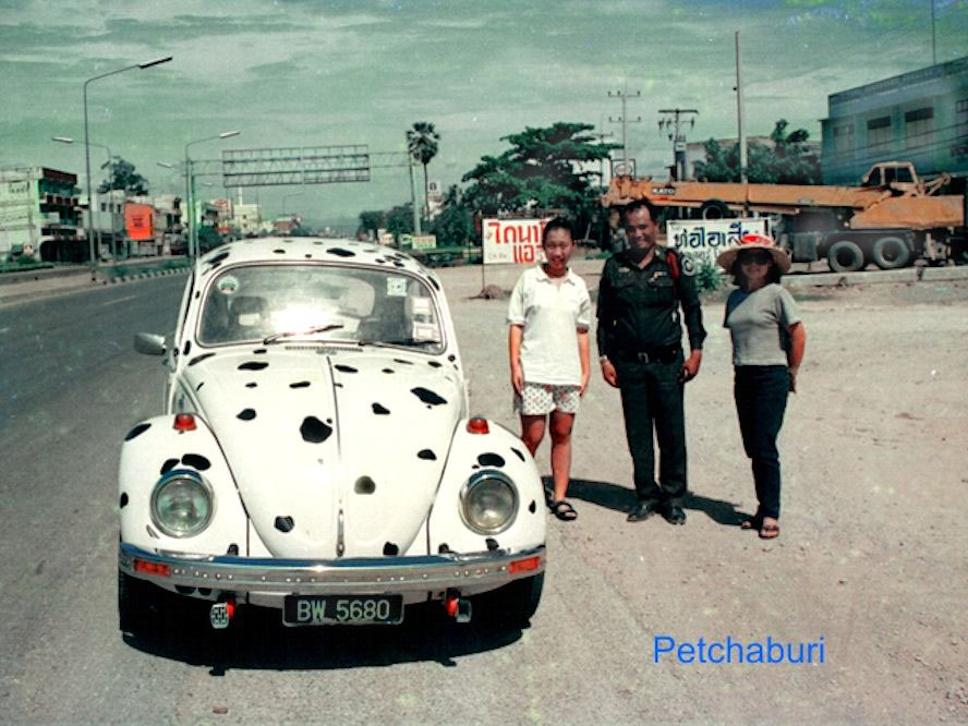
Petchaburi. Yes - we
are now in Central Thailand. Petchaburi meaning the "City of
Diamond" is bordered by Burma on the west and gulf of Thailand
on the east. The province boasts of its famous Kaeng Krachan
National Park which is nearly half the size or land area for
this whole province From then on, this city became
the trading post between Burma and Ayuthaya. While the great
temples were later destroyed, Petchaburi is still known as
"Living Ayuthaya"
In our
traveling days, we had stops in Petchaburi on 3 occasions. There
were stop over breaks and not fot overnight stay 16.2 The Keang Krachan NationalPark
|
Isthmus Peninsula - East Coast
|
Prachuap Khiri
Khan is another province inside the Isthmus of Kra land belt. The
provincial capital also going by the same name is 240 km south
of Bangkok. it is bordered by Petchaburi province in the north
and in the south by Chumphon Province. In the west it shares the
country's border with the Tanintharyl region of Burma
Land traffic between Bangkok and Surat Thani, Prachuap Khiri Khan is a mid-point stop over point . Worthwhile stopping by but not as spending a couple of days type of province 15.1 The Dan Sing Khon at the Burmese Border 15.2 The Khao Chong Krachok Temple 15.3 Hua Hin town
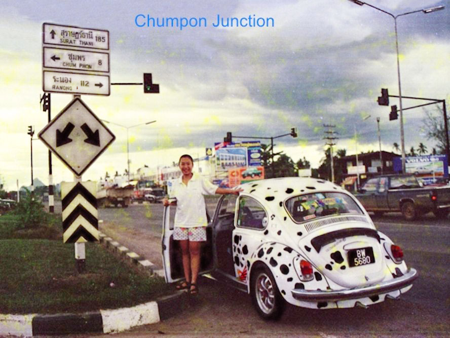
Chumphon is on the
east coast of southern Thai province on the narrow isthmus of
Kra. This province is known for its Corel reefs and a very long
provincial coastline dotted with beaches. The provincial capital is Chumphon City has a number of strategic view points. Among them - Khao Dinsor. This is highest point for Chumphon. A Mecca for bird watcher in the months of October and November. They have the Raptor Watch that an event all bird watchers must not miss. Another viewpoint would be Khao Matsee for an excellent aerial view of the estuary area
Chumphon had become a nostalgic city to us. For nostalgic reasons and using the Raptor Watch as excuse I continued to pick Marokot Hotel as my hotel Though for reasons not known to the famed Princess Finger Banana has lost its lustre. Lastly my friend, Ping Su's father worked here in Chumphon under the Japanese. 14.2 The Princess Finger Banana
14.3 The Khao Dinsor Raptor
Watch
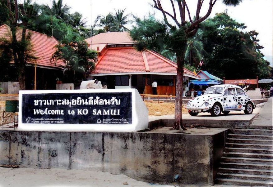
Surat Thani is a rural
province on the east coast of Southern Thailand. Seating right in
the Gulf of Thailand with a huge curved bay. The destination is
famous for its Ang Thong Marine Park and the very touristy island of
koh Samui Well known or popular in the region. Monkeys were trained to harvest coconut.
Pasar Malam in Surat Thani left a better impression in our mind when compared to the touristy Samui Island Had wonderful time staying in that same hotel on all occasion. Incidentally Surat Thani is an essential stop after 500 Km straight drive from Hat Yai and lies smack mid- way to Bangkok 12.1 The Monkey Training School 12.2 The Night Market of Surat Thani 12.3 The Don Sak Ferry crossing 14.4 The Wang Tai Hotel i Surat Thani 14.5 Tour of Samui island
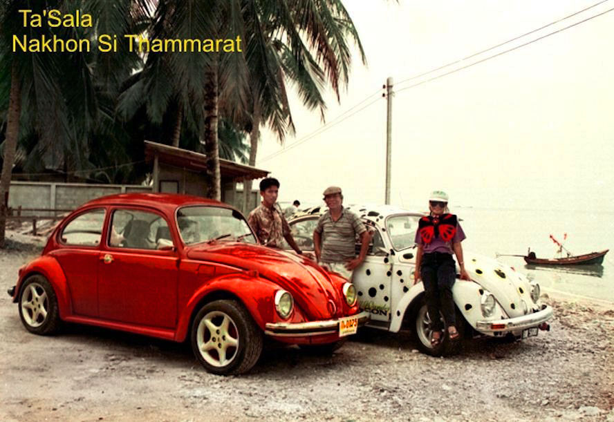
The Nahkon Si Thammarat
Municipality is the provincial capital. It is 610 Kms due south
from Bangkok The province is on the east coast of southern
Thailand. It is a small province compared with those in the
north. The province has an area of 22,56 sq Kms and a population of 102,152:
inhabitants. Oh! This is already the second largest
province in Southern Thailand This is one of the oldest cities in Thailand, with a rich history dating back over a thousand years. It was once the capital of the ancient Kingdom of Ligor, and remnants of its historical past can be seen in traces in various temples, ruins, and artefacts scattered throughout the province The Wat Phra Mahathat Woramahawihan temple is one of the most important religious sites in southern Thailand, housing a sacred relic believed to be a tooth of the Buddha. The Chedi (stupa) within the temple compound is distinctive for its layered, bell-shaped design, and it is a major pilgrimage site for Buddhists. The province is also known for its traditional healing practices, including herbal medicine and massage therapies. Many locals still rely on traditional remedies passed down through generations to treat various ailments and promote overall well-being.
"Nahkon" as everyone called it remind us about the good food, the nice Garden Inn hotel and to he Monk in Wat Phra Mahathat Woramahawihan 9.1 The Garden Inn Hotel 9.2 The Ta'sala town Stop over 9.3 The Wat Phra Mahathat Woramahawihan Temple
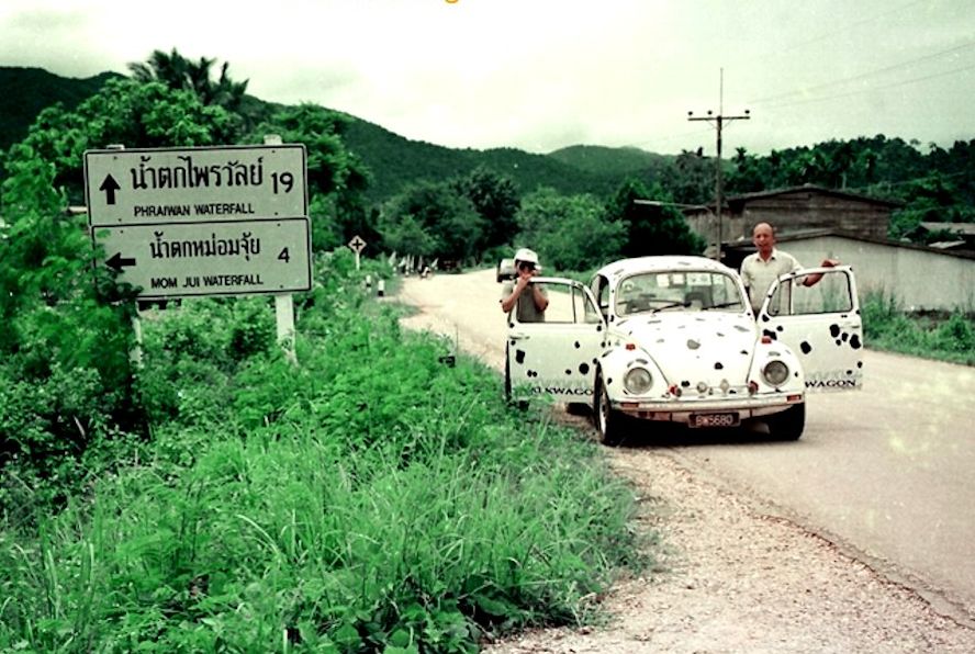
Phattalung, a beautiful town with the lake originating from Songkhla, is famous for two art forms, Manora and Shadows Play. It occupies and area of 3,424.5 square kilometers and administratively divided into 8 Amphoes and 2 King Amphoes. They are: Amphoe Muang, Khao Chaison, Khuan Khanun, Pak Phayun, Kong Ra, Tamot, Si Banphot, Pa Bon, King Amphoe Pa Phayom and King Amphoe Bangkaeo. The area is mountainous and forested with a high plateau in the west sloping down towards the east through Songkhla Lake. It borders on Nakhon Si Thammarat and Songkhla to the north, Songkhla to the south, Songkhla Lake to the east, Trang and Satun to the west.
Well known in the South as the town of the hollow hill, is located
on Trang-Songkla Highway some 840 Kms. from Bangkok and 56 Kms.
fear Trang. Entering the town of Phattalung, one can see the "hole-in-the-heart"
hill located in the just beside the city as if it is the icon of
Phattalung. Trail Head - Mon Jui Waterfalls A souvenir picture with the Road sign
7.1 Khao Oh Thalu The "Hole-in-the Heart" Hill 7.2 The Thale-Noi Inland Lake & Wetlands Area 7.3 More Waterfalls in Phattalung 7.4 Mon Jui Waterfalls 7.5 Phraiwan Wateralls
The land lock province
of Yala in another one of the Muslim dominated places in Thailand
in the deep south. Better known to Malaysian, would be it's city
- Betong at
the Perak border. Betong is 1198 km south of Bangkok, 130 km from
Provincial capital Yala and 263 km from Hat Yai. Border Crossing @ Betong Thai side - Crossing over from Pengkalan Hulu formerly known as Kroh.
Travelling within Yala Province was a long trip and also a lonely drive. The surroundings on both sides were quite rural and giving a sense of uncertainties. Going into Betong from the Malaysian border was a breeze. This border tourist town is just 12 Kms from the country border. In all my trips, I was there in Yala for the Waterfalls. Eventually I was disappointed that most of Waterfalls listed were:- "baby" Falls, 2.2 The waterfalls of Yala 2.3 Wat Na Tham temple in Yala
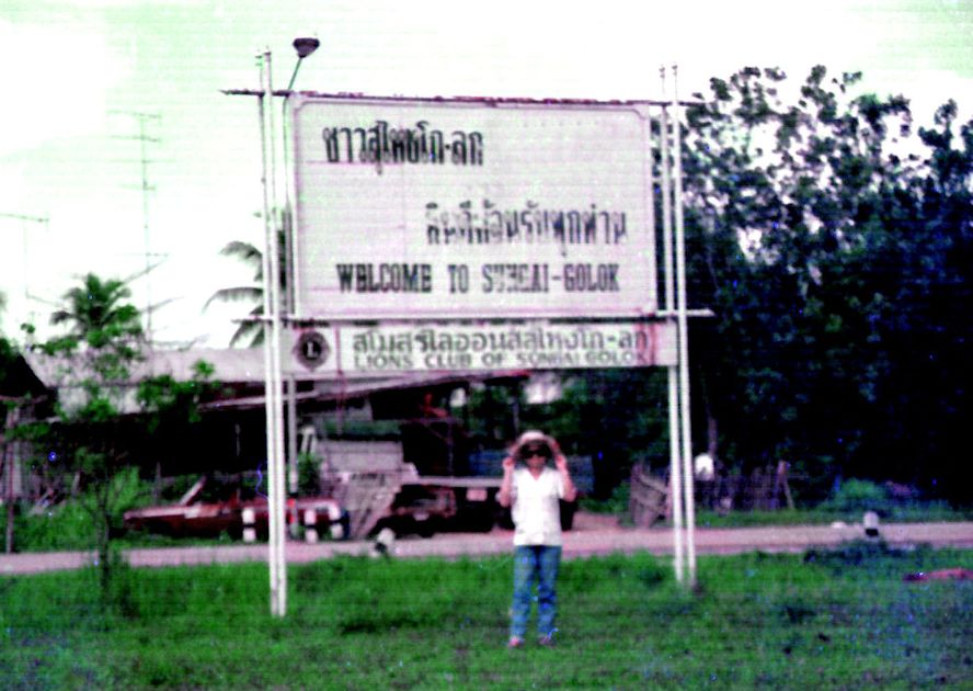
We are all too familiar Sungei Golok. Across the border from the Kelantan side, is the Thai town of Sungei Kolok. It is 1,190 kms south of Bangkok. This town is in the province of Narathiwat . The province has a land area of 4,475 sq kms and a population of 802,474 inhabitants. Narathiwat was part of the semi-independent Malay Sultanate of Pattani paying tribute to the Thai Kingdom of Suhkothai. In 1909 Narathiwat was fully integrated into Siam by the Anglo-Siamese Treaty. Negotiated with the British Empire Amphoe Su-ngai Kolok is the largest town in Narathiwat and commercial center for the province. They have nice beaches but with low patronage. Remembering that the population is predominantly Muslim and using the Jawi language, this province is in the group of the 4 provinces in deep south where security is the main concern Signage at Narathiwat Luckily found one - not a good example too
There is nothing spectacular about Golok or Kolok as they called it in Thai, the town had a couple of main streets and accompanied with am small shanty township. But Narathiwat is one of the border Provinces I need to cover . More so after the millennium times. Hala Bala National Park is the name to go for Hornbills 1.1 The Sungei Kolok Crossing 1.2 The Hala Bala Wildlife Sanctuary 1.3 The Khao Kong big Buddha temple
|
Isthmus Peninsula - Andaman Coast
|
Ranong is a town
and Province in the southern part of Thailand It is 586
kilometers south of Bangkok and in 2005 had a population
of,16,263 inhabitants. It is the most northerly province along
the Andaman coast Well known for its rainy weather 8 months in a
year This is
basically as hokkien speakingcounty
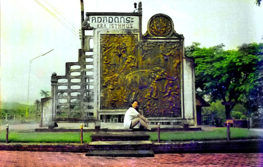
We were mesmerized by the sheer size of the fish market in Ranong and so thrill to meet up with the Punyaban Waterfall which was just beside the Trunk Road. Those excitement was quickly overshadowed by the sight of the monument to mark to the Isthmus of Kra. We made it to an important landmark. That was rather unexpected 13.1 Photography at the Isthmus of Kra 13.2 The Wholesales Fish market 13.4 The "Ninth Emperor" celebration in Ranong 13.5 Our Hotel in Ranong 13.6 The Punyabun Waterfalls
Phuket Province has a land area of 543
sq Kms and a population of 416,582 inhabitants. It is the second smallest
province in Thailand
For historical sites, see the remains in the old town
that are still today, these are
relics left behind from its mining era. The Chinese influences here is very
strong evident by the numerous shrines and restaurants in town. The
chinese community is big, they brought along their traditions. The
festival of the Nine Emperor deity which is still celebrated
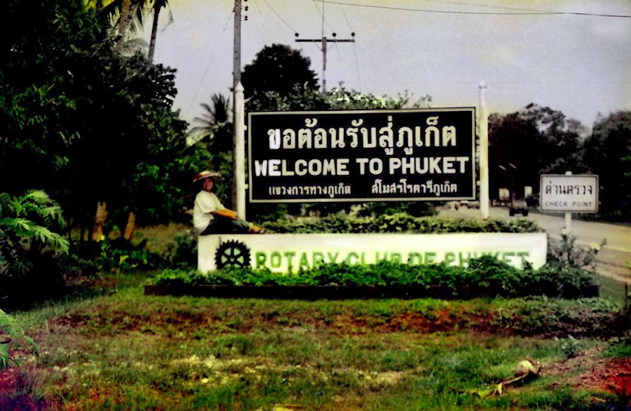
annually Phuket being a big Island is blessed with having countless quality beaches like Rawai, Patong, Karon, Kamala, Kata Yai Kata Noi. Laem Phromthep is the palce to get your Sunset pictures We were in Phuket Welcome signage after the bridge
Phuket is a touristy destination that does not offer much of the features that I was seeking. Anyway it is inevitable to be in Phuket as most travelling companion liked the idea to be driven into Phuket. My impression of the province was deeply etched with the super sweet pineapples that we harvested ripened on the plant 11.1 The Causeway at Phuket 11.2 Surin and Kamala beaches i Phuket 11.4 Phuket Town
Phang-Nga is in southern Thailand have
its shore on the Andaman coast. The province has a population of
268,240 inhabitants living in a land area of 4,171 sq Kms The city is 788 Kms from Bangkok and has chosen it's land mark is in the form of a crouching elephant, which is one of the limestone features in town..
While there is not much attraction in
town, the province Phang-Nga is famous for its iconic off shore islands
namely:- the two Surin islands and the Similan Islands, known for
scenic beauty and good dive sites. Khao Tapao This is my most favourite spot in the entire Thailand.
Phang-Nga is nearer to Malaysia, This is another Province that I visited more times than I liked. All because of the different groups whom I must show to them - the famed James Bond Island 10.1 Birding in the mangrove forest of Phang-nga 10.2 The James Bond Island Khao Tapao 10.3 Ko Panyi the Muslim fishing village
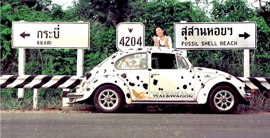
Krabi gives me many fond memories. Until now in 2021, there was not much infrastructure developments, other than the roads. So over the last 20 odd years had passed. The city has changed sure! Heavier traffic which was non existence in 1995, More modern amenities. I still love the "Krabi town" that I found in 1995. Small provincial capital, layback moods and basic facilities. Looking back, It was towards the last quarter of 1995, I took my newly acquired "Dalmatian Beetle" and did a solo trip straight from Petaling Jaya direct to Krabi. A drive of almost 1,000 kilometers. Passing through the customs at the border, learning of the road system in Thailand and plotting my way through 4 provinces. By the time, I was there in Krabi by the late afternoon, I found myself a resort hotel. Right in town. Got a whole small chalet, one room all to myself. The only guess there that evening. Long day and long drive. I went to bed before 9pm. Around 11.30pm I was awoken with hairs all standing The fear was too much to bear. Without investigating, I picked up my barang, head into town center to look for a hotel. Luckily got myself a room at midnight. Next day, did a short drive to Ao Nang Beach and I made an early start for the return journey leg. Way to Ao Nang Beach This is my most favourite spot in the entire Thailand. First time I had my car in Thailand, First time having the car with Thai road sides.
8.2 The Fossil Beach / Su-saan Hawy 8.3 The "Tiger" Caves or Wat Tham Seua 8.6 Tham Bok Koroni National Park 8.7 Tham Lod Mangrove Forest
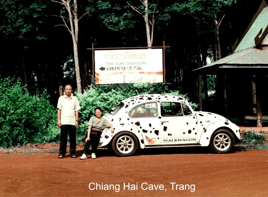
In the 90's, when I started to learn about this place Trang as a Province Trang, the people there very proud of their twin heritage - The imported Jacaranda trees that were planted in their parks and the presence of Dugongs in their warm tropical seas. As I understand more, they are also famous for their Ko-pii shops and stalls by the roadsides. At that time the city has a population of only 50,000 people. Town area almost twice the size of our Ipoh town. The first thing I wanted to know about Trang or rather about Thailand was the Tuk-Tuk taxis. This was my first personal outing to Thailand and Trang was the first town that I was in. Up till these trips, I have never been to Hat Yai! Visiting Chiang Hai Cave
6.1 Ao Muk Emerald Bay Caving adventure 6.3 Thailand's Cloth manufacturer 6.4 Explore around Trang Province 6.6 The Klong Lamchan Waterbirds Sanctuary 6.7 The Pak Meng Pier -Departure into Andaman Seas 6.8 Visiting Trang - Here I come 6.9 The Waterfalls in Trang Province
Songkla Songkla is a province
in Southern Thailand also known as Singora, and a capital of the
same name It is bordering Malaysia Songkla lies 968 km south of
Bangkok and had as population of 61,758 inhabitants. The largest
city in Songkla is Hat Yai
Around Songkla Province I said there were two destinations I avoid in my travel with VW and they were Bangkok and Hat Yai. Easier said then done. When I did other trips with different groups and when I was not using the VW, I had no choice but to spend over night in Hat Yai and as a result, I made Lee Garden Plaza as one of my favourite hotels 4.1. Ferry across Songkla Lake 4.3. The Lee Garden Plaza -my preferred place 4.4. The Thai Styles of Road signs 4.5. The Samila Beach in Songkla 4.6.Tinsulanonda Bridge across Songkla Lake 4.7.The Ton Ngah Chang Waterfalls
Satun Satun Province in
southern Thailand is the most southern Thai province along the
Andaman Seas. It's provincial capital of the same name is 980 Kms from Bsngkok Generally a very rural locality but behold, to
nature lovers it is a province with lots of world class sites of
unparallel beauty The Pak Bara Pier This is the departure point to Ko Tarutoa
Satun - again I say though very close or sharing bordered with Malaysia, the province seemed so to be so Ulu, yet it is a haven to those seeking adventure and those who love outdoor plus adventure 5.1 The Thale Ban Nature Reserve 5.2 The Tarutao & the Ko Lipe tours 5.3 Go caving in the Ohu Pha Ptvh Cave
|
|
Several years ago, the initiative to create the "Dalmatian Beetle in Thailand" page was set in motion. Unfortunately, its progress never advanced beyond a nascent stage. Now, three decades later, I find myself tasked with wrapping it up and recounting its stories. Over time, many of the cherished pictures have been displaced.
Finally completing this page, I must reiterate its purpose: to showcase the myriad places the "Dalmatian Beetle" led us to in Thailand, accompanied by their peculiar names. Along the way, I took the opportunity to update myself on these locations. Many have faded from popularity, their appearances altered by the passage of time. It's fascinating to observe how these places once looked, each name and scene evoking memories of the experiences we had there. The pictures themselves are presented without any particular order or sequence, reflecting the diverse array of trips undertaken, sometimes revisiting the same locales multiple times. This compilation serves as a testament to the journey undertaken and the memories created along the way.
|
|
|
With Will Will Wander |
|


.jpg)